Before the hike really starts, they have a nice area at the top that has bathrooms, picnic tables, a shaded picnic bench area (which you will appreciate after the hike, trust me!), and a great view of the park. There is also a yurt that has park volunteers willing to answer any questions you may have. It also has many examples of flowers, rocks, birds, etc. that you can find in the park. It was interesting to just take a peek at before starting the hike.
Once you start going downhill to start your hike, there is a cute little brick area that has a little info table about the history of the park. It also has a few benches there for you to sit at and take some scenic pictures if you want. After the hike was over, I wanted to tell people to just sit at that area and then call it good! Only semi-joking there.
From there, you head down the Chute Trail, which leads to the beginning of both the Misery Ridge Trail and the River Trail. At the bottom of the Chute Trail, there is an open, grassy area that we definitely utilized after our hike. They had a sprinkler going that we ran through to cool down, which felt incredible! There is also another bathroom, an information board, picnic benches, water fountain, and a volunteer at the bottom of this trail. While we were there, the volunteer was holding a snake that you could pet. He also had an information board on snakes that you could find during your hike. This does include rattlesnakes! We didn't run into any snakes at all while on our hike. We did stay specifically on the main trails for that reason though.
After crossing the bridge at the bottom of the Chute Trail, you have to make a choice between left and right. Left being the River Trail, and right being the Misery Ridge Trail. We chose to start with the River Trail, and loop back around to finish on the Misery Ridge Trail. Both of these trails combined equals a three mile hike, but don't let that fool you. It may only be three miles, but it's hot and steep and painful!
 |
| Misery Ridge Trail |
 | ||
| Off the side of the River Trail |
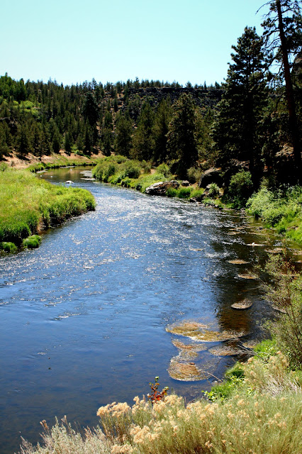
The River Trail, overall, is a pretty easy hike. It doesn't have any huge inclines or anything like that. It's pretty straightforward and provides a great view of the river and the beautiful sound of trickling water. There are a few benches along the way, but not too many. There are quite a few small side trails that lead down to the river too, if you feel like putting your feet in or doing some fishing like my dad did. Just a side note here for those who don't know, my dad fishes catch and release. So, no fishes were harmed during this process. We were also warned not to take out fish from this river anyways, because apparently the farm land washes down into this river and puts chemicals from fertilizers into their system.
Once you turn the first corner of the River Trail, there's a huge rock that is perfect for a family picture, in my opinion. I had Sophia pose on it as an example for you, which she was more than willing to do. The different textures and colors of the rocks just create a great background. Plus, who doesn't love climbing on rocks?
Just a minute or two farther down the trail, we looked over across the river and saw a few rock climbers! The rock they were climbing was nothing compared to most of the other rock climbers we saw that were literally scaling the sides of the main rocks in the park! It was interesting to see up close though. We guessed it was more of a "practice" or warm-up rock before going for the big stuff.
On this trail, you'll see several side trails that lead up to the sides of the rocks. This park is very well known for rock climbing, which became very apparent to us along the way. You will also see many different birds and wildlife. Sophia spotted quite a few little lizards.. or some sort of reptile. Sophia called them Geckos, but I wouldn't have a clue if she's right or not!
After going down the River Trail for quite a while, I looked up and noticed these weird "homes" attached to the bottom of the rocks! They were huge, and looked kind of like gigantic bee hives. We thought possibly for bats or some other animal. If anyone reading knows what animal they are home to, please leave me a comment! It was incredibly interesting to me, and I am still curious to know what they belong to.
The backside of the park was absolutely beautiful. Looking out on the opposite side of the river was just gorgeous! On the top of the cliff-side, we saw a few huge houses, which we came to realize are really common out by this park. The higher the trail went, the more huge, mansion-sized houses we saw. I couldn't stop looking at the amazing view, though. It became more and more breathtaking the farther we went on the trail.
We were planning to take the entire River Trail, but then we noticed there was another trail that also led to the Misery Trail. This in-between trail is called Mesa Verde. It led to "Monkey Face", a famous spire at this park, which I was extremely excited to see. Our first view of it definitely looks like an actual monkey face! It was humorous and only seeing it from a far distance at that point really encouraged us to keep going so we could get a closer view of it.
After reaching the Mesa Verde trail, there was a pretty big incline. We figured the Mesa Verde trail is probably a much larger incline (but faster) than if we would have kept going on the River Trail. You can really get a feel for how much of an incline this was based off of the pictures I took of the mountains. The first picture I got of the mountains, it was partially covered by trees. By the time we reached the top of the trail, the treeline was much lower than the mountains.
The stretch up to the top is so difficult here. It's just such a steep incline that it's hard to climb and breathe! We started realizing that everyone was going the opposite direction of us, so we thought maybe we should've gone the other way, but I personally prefer to climb up something steep than to slide/fall/roll down it! There was one woman with a dog that was pulling her so much I thought for sure he was going to pull her straight off the side of the trail! I was starting to ask for more water breaks once we started this incline section too. Luckily there ended up still being great spots for poses and scenic views that were worth stopping for!
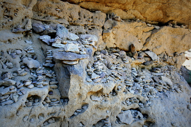
Under Monkey Face, there were these weird rock formations that had tons of holes in them. It looks like most people stop here for a break, because there are some hand-made rock designs there. I thought it was worth looking at though, because of how odd it is! Besides, we all know I wanted another break from that dreaded incline.
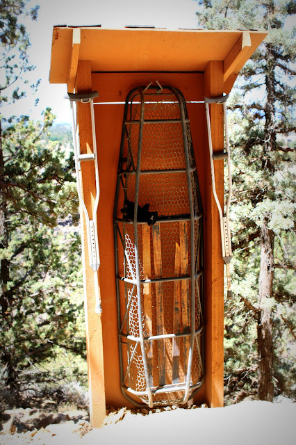
Just when I thought it couldn't get any worse, it did. We reached Misery Ridge Trail, and once I saw the sign where it said "most difficult", I was ready to crawl all the way back down the way we came. Sophia really wanted to continue on, though. And the mountain view was still getting so much better that I really wanted to see the top of this place too. It couldn't be that hard, right? Oh wait. Then I noticed the little rack that holds a bunch of crutches and a stretcher. Yeah, that's reassuring!
Once you hit the Misery Ridge Trail, you start to see the other side of Monkey Face. We decided it looks more like an ape on this side of the spire. There were some more great rock formations along the trail, and it was at this point that I realized I had not seen any flowers! I saw one teeny tiny flower poking through the dirt at one point, but that really was it. I was somewhat disappointed by that since I had seen so many examples in the information yurt ahead of time.
This incline was even worse than the previous part! Sun beating down on you while you hike up a steep, narrow trail is the worst thing ever. I just kept telling myself the top will be worth it. It will be worth it. I am a big complainer, though. Which Sophia kept lecturing me for, even though I could tell she was exhausted too. Her rosy cheeks were bright red going up this section, and she didn't give me her little sassy attitude for taking breaks like she had previously. Looking back now, this section of switchbacks was actually pretty short. But you go up so much in such a short distance that you can really understand why it was so painful and literally took your breath away. On the last switchback, there was a rock shaped like a chair that Sophia took advantage of during one last break before the top.
Finally, we made it to the top! There was instantly big gusts of wind that felt absolutely fantastic. Sophia commented that she wished we had that wind the whole time, and I definitely had to agree with her on that one! I happened to glance over at the top of Monkey Face, and noticed there were two men on the top of it! In my opinion, that is just insane. We were so high up, and I even had my legs shaking from how high we were just on the flat ground area that I was on! I couldn't imagine sitting on the top of that rock and having lunch and then realizing I had to get back down somehow. I'll leave that type of adventure for the crazies!
Well, my hopes that the view would be worth the misery of the trail came true! It was stunningly beautiful. Every direction you looked was just perfect. The sky, the mountains, the houses, the land, the rocks.. it was all just unbelievable. How and why someone felt the need to bring a bench all the way up to the top, I don't know, and I don't even want to imagine having to do that! Either way, it was nice to have it there, and I'd like to personally thank whoever was put through the torture of taking that up there. I do hope you were paid well for it!
And then, before I even had a chance to really get my breath back, we were starting to travel back down the other side of the rock. I peeked over the edge to see what this trail looked like in comparison to the other side of Misery Ridge, and it looked even worse! I couldn't believe it. I am not one for going downwards on a steep trail. I did get a little bit of that Vertigo feeling on this part. Sophia, on the other hand, had no issues with the heights.. which you can see with her crawling all over the edges!
Luckily, it was easier than I thought. There were a few spots where I tip toed down and slid a bit, but they had tons of stairs built in on this portion, which made it go a little faster. Sophia was pretty far ahead of us during this stretch, so hey, maybe I'm just slow. I think she was just ready to be done with the hike at this point though, which could've given her that extra bit of speed at the end. Honestly, I couldn't blame her. After seeing the top, no other views could beat it, so the rest of the hike was just extra unnecessary walking distance for us! Are we pathetic or what?
Ah.. There it was. The finish! It was still a little steep here, but the fact that I could finally see the end made me kick my butt in gear too. I could see the volunteer snake man at the bottom of the Chute Trail turning on the sprinkler on the grass and told Max that I had to go through that when we got down there.
Right at the very end, I somehow talked myself into taking a few more pictures. The rocks looked so cool here! They were white and had holes in them just like on the other side of the park, but they were much bigger. Big enough to take photos in. So of course I had Sophia pose one more time. This time she wasn't so willing, but I got her to do it!
And then we were done! Well, basically. I was relieved once I made it to the bridge, and then realized that the Chute Trail was more of a climb than I originally remembered. I was out of water, tired, and already thought I was done by that point that it ended up being more difficult than it probably should have been! We utilized that shaded area at the top and had some snacks to get some of our energy back. We spent this time watching all the people coming back from the hike that we had passed along the way, and told the people who were just starting the hike to turn back now before it's too late!
I tried to decide which direction for this loop hike would be better, but I honestly can't decide. We had it easy at first, and got destroyed at the end. But my question is this.. would it have been better to start with the painful part, and then go with no energy for the River Trail portion? I'm not sure. And I don't plan to do that hike again, so I won't be able to tell you in the future either! Sorry, but this is a once-in-a-lifetime type of hike for me. The view was absolutely amazing and worth the pain, but only worth the pain once!
I would recommend going on this hike earlier in the day so that it is cooler, and definitely make sure you are completely prepared. Wear the right clothing, pack multiple bottles of water, and bring snacks to keep your energy level up. Oh, and don't forget the dang sunscreen! No matter what, just make it to the top. The top of this hike just makes it all worth it, and I promise you will be happy you did it!
See you on the trail,
Brittnee


